KONECTIS TRACKING INTERFACE

Tracking platform features
This tool allows you to visualize on the internet the location of goods and people equipped with a geolocation beacon.
But not only... you can freely enjoy other functions.
The tracking interface does not require the installation of specific software. Just go to the following address on the internet: www.konectis.com.
You will need to enter your login and password that you defined when you subscribed.
It's simple and you can share it with your family and friends. In a few clicks, you can create a reserved access for them so they can follow you at any time. It's reassuring to know that someone is looking out for you!
New for navigators: Reception of GRIB weather files
Thousands of them trust us! The Konectis platform is also known as www.whatusea.com
View our customers' active trackers in real-time on www.konectis.com.
Don't hesitate to zoom directly on the interactive map!
For confidentiality reasons, information concerning the trackers has been removed.
Note: not all interface functions are visible in this demonstration.
FUNCTIONS
This tool allows to locate goods and people equipped with a tracker on the internet via our dedicated tracking portal.
The tracker is in direct communication with Globalstar, Inmarsat, Iridium satellites, and GSM networks which transcribe its position on www.konectis.com.This position is only visible to its owner, who can grant private access to family or collaborators.

The applications are multiple:
- Track and locate property or people on "Google" maps,
- Be locatable in case of distress,
- Receive GRIB files by email based on the boat's position,
- View the historical route,
- Integrate a link from our interface into your own website or blog,
- Define an authorized travel zone for the property,
- Configure alerts in case of unauthorized movement of the equipped property,
- Access weather news for the next 3 days worldwide.
- Possible options: intrusion detector,
- Receive periodic reports – custom configuration – as SMS/email, etc.
- The www.konectis.com tracking interface is accessible upon subscription.
LOCATION
- Tracker location at all times (Green icon),
- Google Maps ® mapping,
- The tracking interface does not require the installation of specific software.
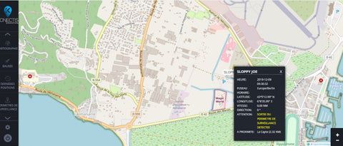
- Tracker location at all times (Green icon),
- Google Maps ® mapping,
- The tracking interface does not require the installation of specific software.
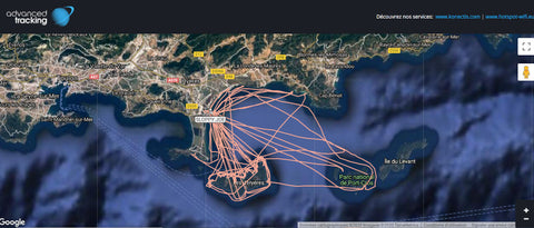
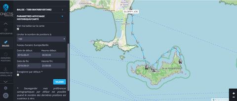
ROUTE HISTORY
- Consult your routes (Blue line on the map).
- Directly define on the platform the route you wish to consult by entering the dates and times that interest you.
- Your route history is saved for 10 years (unless subscription is interrupted).
REMOTE MONITORING
Simply define a perimeter directly on the map around the beacon.
A few clicks, very easy to use.
You are immediately notified by email and SMS when the beacon leaves the zone.

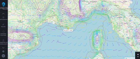
WEATHER
Complete real-time weather forecasts.
GRIB files sent automatically by email based on your boat's location.

MAP INTEGRATION FOR BLOG OR WEBSITE
Integrate our map with your route history on your blog or website.
Your friends will be able to follow you even more easily.
This is a free service we offer to our subscribers.